


Monitoring the Atlantic: In-Situ Aqua TROLL 100 Joins a Solo Ocean Crossing
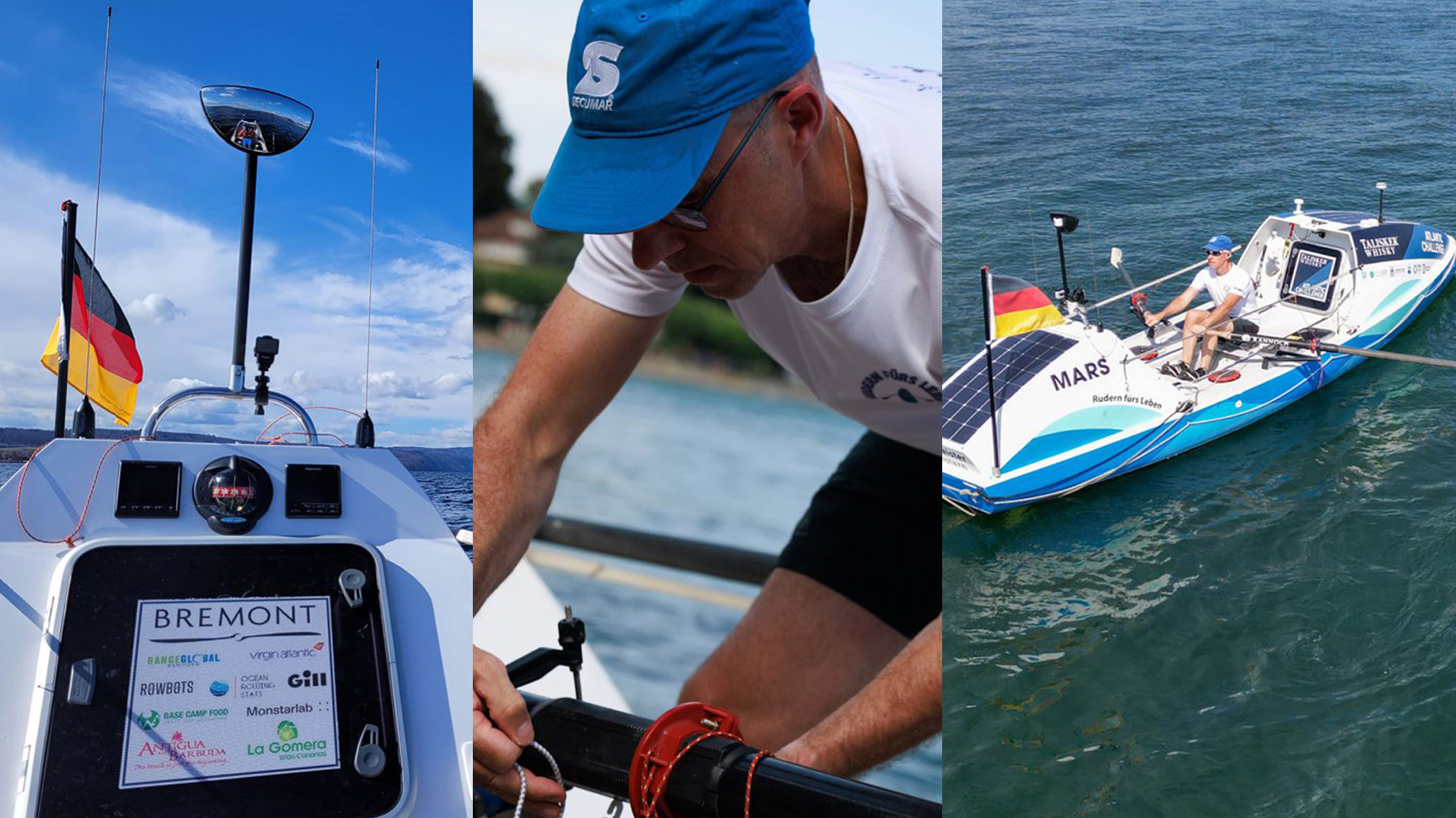
The open Atlantic Ocean presents a formidable challenge, even for experienced sailors. In the World’s Toughest Row Atlantic Challenge, competitors face approximately 3,000 miles of open water, powerful winds, towering waves and weeks of sustained physical effort. For Martin Stengele, the challenge is even more demanding: he is rowing solo.
But Stengele’s journey is about more than endurance. By taking an In-Situ Aqua TROLL 100 along for the crossing, he is also turning his voyage into an opportunity to collect environmental data across a vast stretch of the Atlantic Ocean.
The project demonstrates how compact water-quality instrumentation can be deployed in unconventional environments to collect measurements far beyond the reach of conventional monitoring programmes.
From Atlantic rower to citizen scientist
Stengele’s connection with the sea began in childhood. Although financial circumstances prevented him from pursuing the maritime education he originally wanted, he found another route to the ocean by enlisting in the German Navy. After four years of service, he joined the crew of the restored training sailing ship Roald Amundsen.
He subsequently pursued a career in sport as a physical education teacher, personal trainer and sports psychologist. That background has helped prepare him for the physical and psychological demands of rowing across an ocean alone, where fatigue, isolation and unpredictable weather are part of the experience.
His decision to collect environmental measurements during the crossing adds another dimension to the challenge. Rather than simply travelling across the Atlantic, Stengele intends to gather data that can help characterise the water conditions along his route.
Using the In-Situ Aqua TROLL 100 at sea
For the project, Stengele equipped his kayak with an In-Situ Aqua TROLL 100, configured to log conductivity and temperature at five-minute intervals throughout the journey.
The Aqua TROLL 100 is a compact water-quality instrument designed for measuring these two parameters. Its use in this project illustrates the value of selecting instrumentation that can collect relevant measurements while operating in a demanding field environment.
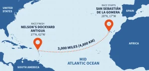
The intended route runs from the Canary Islands to Antigua, crossing a substantial section of the mid-Atlantic. As the kayak moves through different locations, the logged measurements will provide a record of how conductivity and temperature vary along the journey.
Unlike a series of isolated water samples, continuous logging provides measurements at regular intervals throughout the deployment. This creates a more detailed record of changing conditions, subject to the instrument’s deployment configuration, sensor performance and the quality of the resulting data.
The approach also highlights an important principle in environmental monitoring: useful data can be collected in unusual locations when the instrument, deployment method and measurement objectives are properly matched.
What can conductivity and temperature tell us?
Conductivity and temperature are fundamental measurements in water-quality monitoring. Although neither parameter provides a complete picture of water quality on its own, both contribute useful information about the aquatic environment.
Conductivity describes water’s ability to conduct an electrical current, which is influenced by the concentration and mobility of dissolved ions. In seawater, conductivity is closely related to salinity, although the relationship also depends on temperature and the composition of the dissolved substances.
Temperature influences physical, chemical and biological processes in aquatic environments. It also affects conductivity measurements, making accurate temperature measurement and appropriate compensation important when interpreting conductivity data.
Together, these measurements can help characterise the water encountered along the crossing. When combined with the instrument’s location and time records, they can show how measured conditions vary geographically and throughout the deployment.
However, conductivity and temperature alone cannot identify every process responsible for a change in the readings. Additional measurements and supporting environmental information may be needed to establish the cause of an observed variation.
The Calima weather event: an additional environmental question
The crossing has another environmental dimension. According to In-Situ’s account, competitors encountered strong winds and a Calima weather event, during which dust and sand from the Sahara are transported over the ocean.
Such events provide an interesting context for environmental monitoring because atmospheric dust can deposit mineral particles and associated chemical constituents into marine environments. Depending on the composition of the dust and the receiving environment, this deposition can influence aspects of seawater chemistry.
Stengele’s measurements may provide useful context for examining water conditions along his route during the event. Changes in conductivity and temperature could help document variations in the measured parameters, but these measurements alone cannot establish whether Saharan dust caused a particular change.
Establishing that connection would require additional evidence, potentially including dust-deposition measurements, chemical analysis and other water-quality parameters.
This distinction is important in environmental monitoring. Measurements help identify patterns and changes, while understanding their causes often requires additional data and careful interpretation.
Continuous monitoring in challenging environments
The Atlantic crossing illustrates several considerations that apply to environmental monitoring far beyond the marine environment.
Deployment conditions matter. Instruments must be selected and installed with the operating environment in mind. In remote locations, access for inspection, servicing and maintenance may be limited.
Measurement frequency matters. Logging at regular intervals produces a time series that can reveal variations which occasional spot measurements might miss. The appropriate interval depends on the expected rate of change, the monitoring objectives and the required deployment duration.
Data needs context. Time, location, sensor configuration and deployment conditions all help determine what recorded measurements mean. Where environmental changes are being investigated, supporting measurements can be essential for distinguishing correlation from cause.
These principles are relevant to long-term groundwater monitoring, river and catchment studies, industrial water-quality applications and remote environmental deployments. Although each application has different requirements, the objective remains the same: collect reliable measurements that can support sound interpretation and decision-making.
Taking water-quality monitoring further
At SME Monitoring, we work with environmental monitoring instrumentation for applications where dependable field measurements are essential. Selecting an appropriate solution means understanding the parameters of interest, the conditions at the deployment site and how the resulting data will be used.
In-Situ’s Aqua TROLL range offers water-quality monitoring options for a variety of applications. Stengele’s Atlantic crossing provides an unusual example of how this technology can be used to collect environmental measurements in a remote and demanding setting.
The project also serves as a reminder that environmental data collection does not have to be confined to established monitoring stations. With suitable instrumentation and a well-defined monitoring objective, valuable measurements can be gathered in places that are difficult to access using conventional methods.
Follow Martin Stengele’s Atlantic crossing on his official journey page and learn more about the World’s Toughest Row Atlantic Challenge.
For information about water-quality instrumentation and environmental monitoring solutions, visit SME Monitoring.