


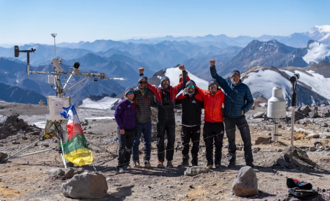
Measuring Solar Radiation at the Top of the World: Lessons from Aconcagua
At almost 7,000 metres above sea level, Aconcagua is an unforgiving place to operate scientific instrumentation.
The highest mountain in the Americas presents researchers with extreme cold, high winds, intense solar radiation and limited access. Yet those same conditions make it an exceptionally valuable location for studying the interaction between the atmosphere, snow, ice and solar energy.
In 2025, an international team of scientists installed five automatic weather stations across Aconcagua as part of Proyecto Wayra: Red de Monitoreo Atmosférico en Aconcagua. The project is a collaboration led by researchers from Argentina’s Instituto Argentino de Nivología, Glaciología y Ciencias Ambientales (IANIGLA-CONICET), the University of Nevada, Reno, and King’s College London.
The stations were positioned at elevations ranging from approximately 4,200 m to almost 7,000 m, creating a network capable of monitoring atmospheric conditions at different elevations across the mountain. Measurements include precipitation, temperature, wind and other meteorological variables, while additional instrumentation is being used to investigate energy exchange at the glacier surface.
The resulting dataset is helping researchers investigate a part of the climate system where instrumental observations have historically been scarce.
Why monitor climate at extreme elevations?
Mountain environments are often described as natural water towers.
Snow and ice accumulated at high elevations provide water to ecosystems, agriculture and communities at lower elevations. In the Andes, snowfall is a major contributor to river systems, making the behaviour of the high mountain environment directly relevant to downstream water resources.
Understanding those systems requires more than measuring air temperature.
Researchers need to understand precipitation, snow accumulation, wind, atmospheric conditions and the energy reaching the surface. These variables interact continuously, influencing snow and glacier melt and ultimately the amount of water released downstream.
Aconcagua therefore provides an unusual natural laboratory.
By placing instruments at several elevations, Proyecto Wayra can capture how atmospheric conditions change with altitude and how those changes influence processes occurring across the mountain.
Solar radiation and the glacier energy balance
Solar radiation is one of the key components of the surface energy balance.
Snow and ice reflect a large proportion of incoming shortwave radiation, while the remainder is absorbed by the surface. How much energy is absorbed depends on factors including surface albedo, snow condition, solar angle and atmospheric conditions.
That absorbed energy can contribute to snow and ice melt.
Measuring radiation therefore helps researchers understand not simply how much sunlight reaches a glacier, but how energy moves between the atmosphere and the surface.
The Aconcagua project includes an energy-balance station on the Horcones Superior Glacier, where researchers are investigating the processes through which glaciers gain and lose mass. According to IANIGLA, understanding these energy fluxes is an important part of understanding current glacier behaviour and modelling potential future scenarios.
When solar radiation exceeds expectations
One of the more remarkable observations associated with the Aconcagua project is the occurrence of extreme solar irradiance events.
Measurements have recorded periods when surface solar radiation can exceed the irradiance theoretically expected at the top of Earth’s atmosphere.
These events, often referred to as over-irradiance, may seem impossible at first. However, atmospheric scattering and reflection can produce short-duration increases in radiation at the surface. Snow, ice and broken cloud conditions can all contribute to this complex interaction.
Kipp & Zonen reports that similar events have previously been observed on Mount Everest, with their recurrence on Aconcagua providing further evidence that these are not isolated phenomena. Understanding these events is relevant to modelling the energy balance of high-altitude snow and glaciers.
For researchers, capturing these short-lived events is only possible when the monitoring system is capable of making accurate measurements continuously.
A missed event is not something that can necessarily be reconstructed later.
The challenge of measuring at nearly 7,000 metres
Installing an instrument on a mountain is one challenge.
Keeping it operating there is another.
The Aconcagua network has already demonstrated just how demanding the environment can be. During 2025, a storm with wind gusts of up to 150 km/h and temperatures below −30 °C damaged instruments at the summit station. A later maintenance expedition was required to repair equipment and restore satellite transmission.
This is a useful reminder that environmental monitoring is about much more than selecting a sensor.
At a remote site, power, communications, mounting, exposure, maintenance and data management all become part of the measurement system.
Snow and ice can obstruct sensors. Wind can damage exposed equipment. Extreme temperatures can affect electronics and mechanical components. Access for maintenance may depend entirely on a short window of suitable weather.
The instruments therefore need to perform reliably when there may be no opportunity to intervene for months.
Measuring radiation accurately
For solar radiation monitoring, instrument selection and installation are particularly important.
Kipp & Zonen develops precision instruments for measuring solar and atmospheric radiation, including pyranometers, pyrgeometers, net radiometers, albedometers and sun trackers.
These measurements support applications ranging from solar resource assessment and photovoltaic performance monitoring to meteorology, climatology, hydrology and scientific research.
The Aconcagua project provides a particularly demanding example of why measurement quality matters.
The Kipp & Zonen account of the expedition identifies the CNR4 net radiometer among the instruments used in the monitoring system. A net radiometer measures the balance between incoming and outgoing radiation, providing information that can be used to investigate the energy exchange occurring at the surface.
That information becomes especially valuable when the surface being monitored is a glacier.
From Aconcagua to Southern Africa
The conditions on Aconcagua may seem a world away from a typical monitoring installation in Southern Africa, but the underlying principles are remarkably similar.
Whether the application is a remote environmental monitoring station, a solar-energy project, an agricultural research site or a hydrological study, the objective is the same:
Collect measurements that can be trusted.
For solar resource assessment, accurate measurements of global, direct and diffuse radiation help establish the available solar resource and support the evaluation of solar-energy projects.
In agricultural applications, radiation measurements can contribute to understanding crop growth, evapotranspiration and local energy balances.
In hydrology and environmental research, radiation forms part of the broader energy balance governing evaporation, snowmelt and surface processes.
In all of these applications, the quality of the resulting analysis is constrained by the quality of the underlying measurements.
Good monitoring starts with good measurements
Proyecto Wayra is a good example of what environmental monitoring can reveal when instruments are placed in environments that have historically been difficult to observe.
A glacier does not simply respond to air temperature.
Its behaviour is influenced by solar radiation, longwave radiation, precipitation, wind, snow properties, surface albedo and atmospheric conditions. Understanding those interactions requires measurements collected together and maintained over time.
The Aconcagua network is helping build that picture.
It is also demonstrating the engineering challenge behind the science. Instruments operating at nearly 7,000 metres must survive extreme conditions while producing measurements that researchers can use to understand processes affecting an entire mountain water system.
From the high Andes to monitoring sites across Southern Africa, the principle remains the same:
Reliable environmental data starts with reliable measurement.
Further reading
Proyecto Wayra and the Aconcagua monitoring network:
The official IANIGLA-CONICET project update provides information on the monitoring network, participating research institutions, station locations and the data being collected.
Kipp & Zonen: Science at the Summit:
Kipp & Zonen’s account of the Aconcagua expedition provides additional information on the extreme irradiance observations and instrumentation used during the project.