


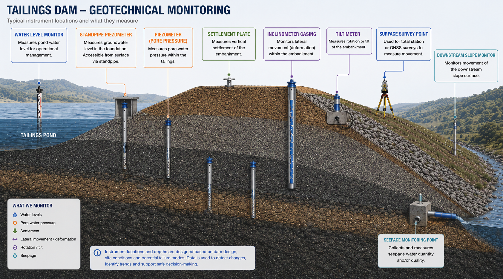
Geotechnical Monitoring: Understanding Ground Behaviour Before It Becomes a Problem
Geotechnical monitoring is an important part of managing risk in civil engineering, construction and infrastructure projects. Structures may be designed to withstand significant loads, but their performance ultimately depends on the ground supporting and surrounding them.
Soil and rock can move, deform, settle and respond to changes in groundwater conditions. These changes may occur gradually over months or years, or develop rapidly during excavation, construction, heavy rainfall or changes in loading.
Geotechnical monitoring provides engineers with the measurements needed to understand these changes and identify potentially significant trends before they develop into serious problems.
What Is Geotechnical Monitoring?
Geotechnical monitoring is the measurement and analysis of changes in ground and subsurface conditions that may affect the safety, stability or performance of a structure or construction project.
Depending on the application, monitoring may include:
- Groundwater levels and pore water pressure
- Lateral ground movement
- Settlement and heave
- Slope movement
- Structural or foundation tilt
- Loads in anchors and rock bolts
- Stress and strain in geotechnical structures
- Ground vibration
- Changes in crack width or displacement
The objective is not simply to collect measurements. The real value lies in understanding how the ground is behaving, whether that behaviour is consistent with expectations, and whether changes require engineering intervention.
Why Monitor Ground Conditions?
Ground conditions are not necessarily static.
Excavation can change the stress regime around a site. Dewatering can alter groundwater levels and pore pressures. Construction loads can cause settlement, while rainfall can increase pore water pressure and affect slope stability.
In a deep excavation, for example, lateral movement of the surrounding ground can place nearby structures and services at risk. In an embankment or dam, changes in pore pressure and settlement can provide important information about its behaviour. Around foundations, differential settlement can lead to movement or damage to the supported structure.
Monitoring allows engineers to establish a baseline and then compare subsequent measurements against that baseline.
This provides a much clearer picture than relying on visual inspections or isolated measurements.
Geotechnical Instrumentation: The Main Parameters Measured
Groundwater and Pore Water Pressure Monitoring
Water is one of the most important variables in geotechnical engineering.
Changes in groundwater levels and pore water pressure can influence effective stress and therefore the behaviour and stability of soil. Monitoring these changes can be particularly important around excavations, slopes, foundations, tunnels, dams and embankments.
Vibrating wire piezometers are widely used for measuring pore water pressure in soils, embankments, foundations and boreholes. Depending on the application, monitoring can be performed manually or integrated into an automated system for continuous data collection.
The important measurement is often not simply the absolute pressure, but how pressure changes over time and how those changes relate to rainfall, excavation, pumping or other site activities.
Lateral Ground Movement and Inclinometer Monitoring
Ground can move horizontally as well as vertically.
Lateral movement is a key concern in applications such as deep excavations, retaining walls, slopes, tunnels and embankments.
Inclinometers and in-place inclinometer systems measure the lateral deviation profile along a borehole or installed casing, making it possible to pinpoint the depth of a shear plane and track how movement changes over time.
Continuous monitoring can be particularly valuable where movement needs to be detected quickly and action thresholds have been established.
Settlement and Heave Monitoring
Settlement occurs when the ground moves vertically downward, while heave represents upward movement.
Some settlement is expected in many construction projects. The concern is excessive, unexpected or differential settlement.
Settlement monitoring can be applied to:
- Foundations
- Buildings
- Embankments
- Dams
- Roads and infrastructure
- Tunnels
- Areas affected by excavation
Monitoring settlement over time allows engineers to determine whether observed movement is within expected limits and whether the rate of settlement is changing.
Tilt and Structural Movement Monitoring
Ground movement does not always remain isolated to the ground.
Differential settlement or ground deformation can cause structures to tilt or move. Tiltmeters can therefore provide another layer of information when monitoring buildings, retaining structures, foundations and other infrastructure.
When combined with ground movement measurements, tilt data can help engineers distinguish between changes occurring in the ground and the resulting response of the structure.
Load, Stress and Strain Monitoring
Geotechnical monitoring can also involve measuring loads and stresses within structural and ground-support systems.
For example, load cells can be used to monitor forces in rock bolts, anchors and struts, while strain gauges and pressure cells can be used in applications such as tunnels and concrete structures.
These measurements can provide information about how a support system is responding to changing ground conditions and construction activities.
Geotechnical Monitoring During Construction
Construction is often when ground conditions experience their greatest disturbance.
Excavation, tunnelling, piling, dewatering and changes in loading can all alter the behaviour of the surrounding ground.
A monitoring programme can provide measurements before, during and after these activities.
This is particularly important when construction takes place close to existing buildings, roads, utilities or other infrastructure.
For example, a deep excavation may incorporate:
- Inclinometers to measure lateral ground movement
- Piezometers to monitor groundwater and pore pressure
- Settlement points to monitor vertical movement
- Tiltmeters to detect changes in nearby structures
- Crack or displacement meters where existing structures require monitoring
The individual measurements become considerably more useful when they are considered together.
An increase in pore pressure accompanied by increasing lateral movement, for example, may provide a very different engineering picture from either measurement considered in isolation.
Geotechnical Monitoring vs. Structural Health Monitoring
Geotechnical Monitoring (GM) and Structural Health Monitoring (SHM) are closely related, but they are not the same thing.
Geotechnical monitoring primarily looks at the ground and subsurface environment around a structure.
Structural Health Monitoring focuses on the condition and behaviour of the structure itself.
For example, geotechnical monitoring may measure:
- Soil movement
- Groundwater levels
- Pore pressure
- Settlement
- Slope deformation
Structural health monitoring may measure:
- Structural strain
- Vibration
- Crack development
- Structural displacement
- Loads and stresses
The distinction is useful, but the two disciplines often overlap in real-world projects.
A structure does not exist independently of its foundation and surrounding ground. Changes in the ground can produce changes in the structure, while structural measurements can help demonstrate how the structure is responding to those ground conditions.
For complex infrastructure, combining both types of monitoring can provide a much more complete understanding of what is happening.
From Measurements to Meaningful Information
A monitoring system is only useful if the data can support an engineering decision.
This means that successful geotechnical monitoring involves more than selecting a sensor and installing it in the ground.
A monitoring programme should consider:
- What needs to be monitored? The parameters should be selected according to the identified geotechnical risks.
- Where should measurements be taken? Instrument locations need to provide meaningful information about the areas of concern.
- What is the baseline condition? Establishing reliable baseline measurements provides a reference against which future changes can be assessed.
- How frequently should measurements be collected? Measurement frequency should reflect the rate at which conditions could change and the consequences of missing a significant event.
- What constitutes an important change? Alert and action thresholds should be established where appropriate.
- How will the data be communicated? Remote telemetry and online platforms can make monitoring data available to engineers without requiring every measurement to be collected manually.
Automated and Remote Geotechnical Monitoring Systems
Modern monitoring systems increasingly combine sensors, data loggers and telemetry to provide continuous access to measurements.
Instead of relying solely on periodic site visits, an automated system can collect measurements at predefined intervals and transmit the data to a central platform.
This can be particularly valuable for remote sites or projects where conditions can change rapidly.
Automated monitoring can also support alarms based on predefined thresholds or rates of change. This allows engineers to focus attention on measurements that require investigation rather than manually reviewing every reading.
However, automation does not remove the need for engineering judgement.
A sensor can report that a value has changed. It cannot automatically determine whether that change represents a genuine geotechnical problem, an expected response to construction activity, environmental influence, or an instrumentation issue.
Good monitoring therefore combines reliable instrumentation with appropriate interpretation.
Long-Term Geotechnical Monitoring After Construction
Geotechnical monitoring does not necessarily end when construction is complete.
Some infrastructure requires long-term monitoring because ground conditions can continue to change throughout the life of the asset.
Dams, slopes, embankments, foundations, tunnels and other major structures may require ongoing observation of parameters such as pore pressure, settlement or deformation.
Long-term datasets also become increasingly valuable over time.
A single measurement provides a snapshot. A reliable dataset collected over months or years can reveal trends, seasonal behaviour and relationships between different parameters.
That historical record can help engineers distinguish normal behaviour from changes that warrant further investigation.
The Value of a Well-Designed Monitoring System
The purpose of geotechnical monitoring is ultimately risk management.
It provides engineers with evidence of how the ground is behaving rather than requiring them to rely solely on assumptions, inspections or occasional measurements.
A well-designed monitoring system can:
- Establish baseline conditions
- Detect changes in ground behaviour
- Identify developing trends
- Provide early warning of potentially unsafe conditions
- Support construction control
- Protect adjacent infrastructure
- Improve understanding of ground-structure interaction
- Provide data for long-term asset management
The most effective systems are designed around the engineering question rather than around the instrument.
The right sensor, installed in the right location, measured at an appropriate interval and combined with reliable data management can turn changes in the ground into actionable information.
Geotechnical Monitoring Is About Understanding Change
Ground behaviour is rarely captured by a single measurement.
The real value of geotechnical monitoring comes from observing how different parameters change over time and how those changes relate to construction activities, environmental conditions and the behaviour of the structure.
Pore pressure, settlement, lateral movement and structural response can each tell part of the story. Together, they can provide a much clearer picture of what is happening beneath and around an infrastructure project.
For civil engineering projects where ground conditions are critical to safety and performance, geotechnical monitoring provides an important link between what engineers expect the ground to do and what it is actually doing.
At SME Monitoring, we provide instrumentation and monitoring solutions for applications where reliable measurements of ground, water and structural behaviour are essential. From individual sensors to remotely monitored systems, the objective remains the same: turning reliable measurements into information that supports better engineering decisions.